


southwestern Sweden mainly for severe wind gusts and tornadoes.A level 1 was issued for central Europe (in particular Austria, Czech Rep., western Poland) mainly for large hail and severe wind gusts.SYNOPSISAn active, baroclinic weather pattern is in place over central Europe, with a surface low pressure area/trough near Denmark stretching south to Italy. A warm and humid plume within this surface trough provides ample fuel for storms with MLCAPE values predicted up to 2500 J/kg by the GFS model, highest over eastern Germany to Slovenia where there is a convergence zone available as well. Higher LCLs and Delta-Theta-E from eastern Germany into Slovenia should enhance severe gust potential. Over western Germany and Denmark instability values are lower but shear stronger.DISCUSSION...southern and eastern Germany...In range of the highest CAPE values, 100-250 m²/s² SREH and 15-25 m/s DLS are available and enhance storm organization (multicell clusters and MCS) and updraft rotation (supercells). Several models develop an MCS or otherwise large blob of precipitation on the north side of the Alps tracking northeastward over Czech Republic into Poland, likely in association with a shortwave trough. Since the model does not take into account storm dynamics, actual MCS may end up more southward/eastward. Severe gusts may be produced by this system. Elsewhere, supercells with large hail and severe gusts are likely. A tornado is also not ruled out, since in large parts of Germany (also westward of level 2, where GFS also computes a second convergence line) LLS ranges from 8-12 m/s and LCL heights are less than 800m. In southern Germany LLS can even reach higher in GFS, but it has to be noted that the computed convection has significant influence on the other parameters here. Corfidi vectors based on GFS suggest an increasingly parallel storm motion to the orientation of the convergence line near the west Poland border, and more backbuilding potential during the night, apparently in reponse to the low level jet. This can enhance local precipitation sums and flash flooding from training convection....northern Germany, Denmark, southwestern Sweden...While CAPE should be lower here, both deep layer and low level shear values are larger and supportive of tornadoes and bow echoes. At the warm front, SREH is enhanced to 250 m²/s². Currently, the overnight MCS from the Benelux is passing over Denmark, with some severe gust potential (bow segment observed at beginning of period over NW Germany). While GFS sketches the best environment at 12Z, this morning MCS can be expected to suppress storm conditions during the afternoon, and it is not sure the situation will recover enough for another round over Denmark. In any case, line-normal shear of 16 m/s and 0-3 km average wind speeds of 20 m/s favor severe gusts, and low level shear remains favorable for a tornado.
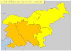
Arso je dal oranžno stopnjo
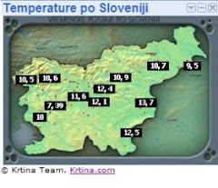
Koroška ,Gorenjska, Štajerska ,Prekmurje, Osrednja Slovenija ,Dolenjska so dobili Oranžno barvo le primorska rumeno.
Opis
Ob 17:30 so se v smeri celja začeli kopičiti nevihtni oblaki in ob 17:45 se je že slišalo grmenje.
Ob 18:45 je padlo par kapelj ter do 20ure je počasi kapljalo.
Med 20:00-20:55 se je dež krepil ter bliskanje(cca.vsake 3 sekunde) in grmenje.
Med 21:06-21:12 je padala tudi toča v velikosti okoli 0,7mm(kot grah) , pihal je močan veter SZ smeri do 70km/h(Arso Ptuj 68,4km/h 19m/s , doma 46km/h 13m/s vendar to ni bila realna hitrost vetra saj merim veter na 3 metrih.Grmenje in bliskanje je ponehalo ob okoli 22:45 uri.
Padlo je okrog 17mm zaradi vetra ni točno.Odbojnost je bila med 50-55 dbz


Ni komentarjev:
Objavite komentar