
Storm Forecast
Valid: Sun 23 May 2010 06:00 to Mon 24 May 2010 06:00 UTC
Issued: Sun 23 May 2010 05:42
Forecaster: SCHLENCZEK
A level 1 was issued for the Netherlands and NW Germany mainly for severe wind gusts and to a lesser extent for tornadoes.
SYNOPSIS
High pressure is centered over the British Channel and a weak upper trough is located over the Black Sea. A shortwave trough will approach from the North Atlantic, moving towards the southern North Sea. In the wake of this trough, cold polar air will replace a warm subtropical airmass over portions of central Europe. Another upper trough, initially located east of the Azores, moves towards W Iberia.
DISCUSSION
...Scotland, NE England...
Over N Scotland, a 30 m/s jet streak at 500 hPa is very close to a region with low-end instability. Right now, satellite images show much mid level cloudiness which will hinder insolation but a few storms may develop during the afternoon. Some storms should become well -organised multicells, capable of producing marginally severe hail and isolated severe wind gusts. The low expected storm coverage precludes a level 1 in this region.
...Netherlands, NW Germany from 18Z until 06Z...
Ahead of the shortwave trough, a weak cold front will form over the North Sea, moving to the SSE. In the vicinity of the frontal boundary, some low-end instability is forecast and QG forcing may be sufficient for initiation. If thunderstorms develop in this environment, they will profit from strong 20 - 30 m/s deep layer shear and 100 - 150 m²/s² SRH3. As the low / mid level wind field is relatively strong, the main threat should be severe wind gusts. Storms may either stay discrete or merge into a bowing line. A tornado is not ruled out as LL shear is strong and the cloud bases should be relatively low. A level 1 should be warranted.
...S Sweden...
In an environment with 15 - 20 m/s deep layer shear, diurnal heating may create a few hundred J/kg CAPE. Some multicells may develop and could produce marginally severe hail. After sunset, convective activity should come to an end as most of the CAPE is surface-based.
...Italy...
Diurnal heating will lead to moderate instability in a weakly sheared environment. Most of the storms that may develop should be briefly organised but a few pulsating storms may produce marginally severe hail. The hail threat should be maximised over N-central Italy. Storms will rapidly diminish after sunset as CAPE vanishes.
...SE / E Europe...
The situation in most parts of southeastern and eastern Europe is nearly the same as it is in Italy. Diurnal heating will lead to locally 1000 - 1500 J/kg CAPE in a weaky sheared environment. A few large hail events are not ruled out but given the sporadic nature of such an event compared to the large area, no threat level was issued. A short-lived tornado cannot be ruled out as well. Peak activity is expected in the late afternoon.
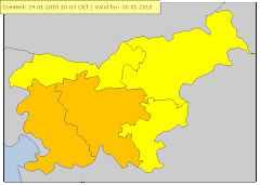
velja od 23.05.2010 10:00 CET Do 23.05.2010 18:00 CET
Nevihte Stopnja ogroženosti: Rumena
en: Thunderstorms are possible, accompanied by local intense precipitation and gusty winds. sl: Možne so krajevne nevihte z lokalnimi nalivi in močnejšimi sunki vetra.
Opis
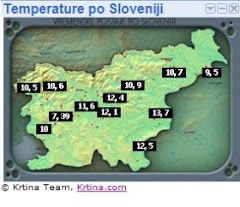
Nedelja,23.5.2010-Prevladovalo je pretežno jasno do delno oblačno vreme.Ob 11:30 padlo par kapelj,med 12:15-12:40 manjša ploha(0,2mm dežja),med 13:55-14:15 močna nevihta z nalivom(odboji 45-50dbz) dež ponehal ob okoli 14:45.Padlo je 4mm v nevihti ,skupaj tako 4,2mm.Najnižja temperatura je bila 10,6.C (ob 2:56) najvišja pa 22,5.C (ob 13:52)Veter je dosegel 21km/h 5,8m/s SZ ob 10:15.Vlaga max:93% (ob 3:00) min pa 48% (ob 11:52)
Rosišče min:9.C (ob 1:44)
Rosišče max:16.C (ob 16:08)


Karte
Padavine


Cape+Lifted index(Cape med 500-600 j/kg , Lifted index pa -2)


Rosišče

Nevihta


Ni komentarjev:
Objavite komentar