VP Orešje pri Ptuju 233 m

VP Orešje pri Ptuju 233 m
HP supercelična nevihta nad Ptujskim jezerom 13.7.2024

sreda, 14. julij 2010

Neurje z hudim nalivom,vetrom in drobno točo 13.7.2010


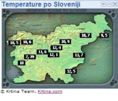
Verjetnost pojavlanja toče(slika 1)


Storm Forecast
Valid: Tue 13 Jul 2010 06:00 to Wed 14 Jul 2010 06:00 UTC
Issued: Tue 13 Jul 2010 05:51
Forecaster: KOROSEC

A level 2 was issued for most of Sweden mainly for severe wind gusts, large hail, tornadoes and excessive convective rainfall.

A level 1 was issued for surrounding areas of level 2 towards the north and western Finland, and to the south across NE Germany and western Poland mainly for severe wind gusts, excessive convective precipitation and lesser extent for large hail.

A level 1 was issued for the Baltic states, much of Belarus, Ukraine and southwards across the eastern Balkans mainly for excessive convective precipitation and locally marginally large hail.

A level 1 was issued for south-central Alpine region including Slovenia and mountainous N Italy, parts of south-central Italy and SE France mainly for excessive convective rainfall, strong winds and marginally large hail.

SYNOPSIS

An intense trough which resulted in widespread severe storms on Monday continues tracking NE-wards across Scandinavia, while another deep trough/upper low enters western Europe and will result in another outbreak sequence on Wednesday afternoon. A weakening mid-level low over Ukraine moves slightly towards SE while slowly building omega-like ridge pushes into central Europe again.

At surface, a strong frontal system associated with the afforementioned robust trough serves as a focus for an outbreak of severe storms across Sweden. The cold front extend southwards into western Poland by the afternoon, while strong WAA ahead of the trough pushes warm front into the northern Scandinavia.

DISCUSSION

... Sweden and areas NE-wards towards north-western Finland ...

Starting early in the day, storms activity will soon continue from the past nocturnal cluster entering Sweden from the SW. A rather strong forcing along the deep frontal convergence will be the focus for the main activity. Rich BL moisture across the warm sector (0-1km mixing ratios up to 13 g/kg) will result in around 1000-1500 J/kg of MLCAPE, overlaping with 20-25 m/s of 0-3km and deep layer shear. Therefore, a well organized deep convection is quite probable. With backing LL flow, quite strong at places especially over central Sweden, around 200-300 m^2/s^2 of SREH3 will result as well as around 15 m/s of low level shear. This all and including low LCLs should there support a couple of supercells with tornado threat, especially if stronger cell could form ahead of the main cold frontal boundary activity. Strong forcing and shear vector mostly parallel to the N-S front orientation seem likely to support a large MCS with a strong squall-line with bowing segments along the front, quite rapidly racing ENE-wards. As such, a threat for severe wind gusts, very intense convective rainfalls and locally large hail will exist.

... NE Germany and western Poland ...

Along the cold front extending from the surface low over Sweden, storm initiation is expected in the early afternoon hours with peak surface heating. Though only marginal instability with MLCAPE between 500 and 800 J/kg builds up within 10-15m/s of deep layer shear. This far south, intiation will be more isolated than further north where frontal boundary is better defined. However, a still relatively strong frontal convergence and some mid-level forcing with backing surface flow ahead of the boundary, will root deep convection. A locally well organized storms will be possible, mostly acting as multicells. Some rotating updrafts could form as well. Strong winds and intense rainfalls will be the primary threat given the more linear mode and training effect of the storms along the front. While a large hail will be limited to the more isolated and intense cells.

... SE France, north and central Italy, southern Austria and Slovenia ...

Placed in the hot and very moist boundary layer, high instability with MLCAPE exceeding 1500-2000 J/kg will result. These areas will again see daytime driven activity in slightly better sheared environment around 10 m/s than previous days. Even the threat for severe storms is rather limited, a low-end level 1 was issued to cover the most intense storms. Given the pulsating nature of the storms and high PWAT values over these areas, excessive rainfall and locally small hail will be the main threat. High delta theta-e culd also support locally strong wind gusts. A small level 1 area was also issued for parts of south-central Italy where similar conditions could support a couple of flash flood events as well. A bit better shear overlaps with instability over western part of level 1 area across SE France and western Alps. There, enhanced risk for intense convective rainfalls, strong winds and large hail exists. With an approaching trough towards the Wednesday morning, strong warm advection takes place from Spain NNE-wards into southern France. An elevated convection seems likely to form along the northwards advecting warm front over SW France during the second half of the night.

... A large area from Baltic states towards eastern Balkans ...

While a large area with weak geopetential heights finally shifts away from Ukraine towards SE, another day of mostly pulsating storms is expected. In the late morning/early afternoon hours widespread convective activity will first take place along the mountainous terrain as well as along the numerous old surface outflow boundaries. With very high MLCAPE and PWAT, but limited deep-layer shear staying below 10m/s, only pulse storms with intense rainfalls and small hail are expected. Per GFS, slightly better shear around 10-15m/s seems over the Belarus and surroundings which could enhance a threat for large hail there as well.

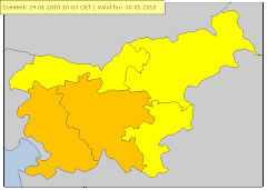
velja od 13.07.2010 10:00 CET Do 13.07.2010 22:00 CET

Nevihte Stopnja ogroženosti: Oranžna

en: Heavy thunderstorms are possible, accompanied by local intense precipitation, hail and gusty winds. sl: Možne so močnejše krajevne nevihte z nalivi. točo in močnejšimi sunki vetra.


Udari strel nad Evropo


Največji odboji(55-60dbz)


Nevihta z močnim grmenjem ,nalivom ,vetrom in drobno točo 13.7.2010

Ob 16:45 začelo močno vlivat,med 17:15-17:22 padala tudi toča s premerom 1cm.Do 17:30 padlo 37mm,do 17:45 pa neverjetnih 42,2mm.Neurje je ponehalo ob 19 uri,skupaj je tako padlo 44,4mm ,max rain rate 235,2 mm/h ob 17:18.Največji sunek je bil 51,5km/h ob 17.19(Arso Ptuj 74km/h)Max odboji nevihte so bili 55-60dbz.Temperatura je iz 33,1.C padla na 19,8.C.


Med 16:45-17:30-37mm(37 litrov na kvadratni meter)
Med 16:45-17:45-42,2mm(42 litrov na kvadratni meter)
Med 16:45-18:45-44,4mm(44 litrov na kvadratni meter)
----------------------
Skupaj:44,4mm

Prihod neurja iz smeri Pohorja


Ni komentarjev:

Naj 5 dogotkov v letu 2012

Naj 5 vremenskih dogodkov v letu 2012


1. Huda vročina in suša v drugi polovici avgusta(15-25.8.2012)
Avgusta sta nas zajela dva močna vročinska vala. Prvi je trajal od 1 do 6 avgusta,najvišja temperatura je bila dne 5 avgusta in sicer 34,7 stopinj C.
Med 15 in 25 avgustom,nas je zajel izjemno hud vročinski val. Ponekod v jugovzhodni Sloveniji so bile temperature tudi do 39 stopinj C. Na vremenski postaji Orešje pri Ptuju je bila zabeležena najvišja avgustovska temperatura in sicer 36,6 stopinj C dne 22.8.2012. Povprečna mesečna temperatura v avgustu je bila 22,0 stopinj C,kar je nov rekord. Med 1-26 avgustom je bila povprečna temperatura celo 22,5 stopinj C. Vročinski val je trajal kar 11 dni,v tem obdobju je padlo le 1,2mm dežja(23.8). V celem avgustu pa samo 24 mm dežja. Zaradi hude suše je začelo odpadat listje z dreves. Po 26 avgustu je vročina popustila.

Slike suše

Tabela max. temperatur med 15-25 avgustom.

Datum
Tmax.
Čas izmerjene temperature
15.8.2012
30,5 °C
17:10
16.8.2012
30,6 °C
16:18
17.8.2012
30,7 °C
18:25
18.8.2012
30,5 °C
16:30
19.8.2012
32,4 °C
17:19
20.8.2012
35,1 °C
16:28
21.8.2012
35,6 °C
17:19
22.8.2012
36,6 °C
17:05
23.8.2012
32,9 °C
18:15
24.8.2012
36,4 °C
16:43
25.8.2012
34,8 °C
17:30

2. Viharni jugozahodni veter 25.12.2012
Izjemno vetroven Božični dan. Sunki jugozahodnega vetra so po nižinah dosegali do 80km/h ,v nekoliko višjih legah pa do 100km/h. Tako doma kot na sosednjem hribu(Sovretova pot 300m) je bil zabeležen nov rekord. Na VP Orešje pri Ptuju je bil največji sunek izmerjen ob 10:09 in sicer 61,2km/h(sunki so bili tudi do 75km/h,zaradi sunkovitega vetra se je konstrukcija vremenske postaje ob večjih sunkih zamajala,zato so bili dejanski sunki nekoliko večji). Povprečna dnevna hitrost vetra je bila 16,3km/h. Med 10:30-11:10 sem z ročnim merilcem(Windmaster 2) meril na bližnjem hribu,kjer je izrazito izpostavljena lega za JZ veter. Izmeril sem rekorden sunek vetra in sicer 90km/h(25m/s) ob 11:02. Omenjen sunek spada po 12 stopenski Beaufortovi lestvici pod močan vihar(10 stopnja). Sunki so bili med 12-14 uro lahko blizu 100km/h.


Slikovna napoved(Vir.Arso)


Podrto drevo ,Orešje-Sovretova pot pri Ptuju.Vir:24ur.com


Modelska napoved največjih sunkov vetra(Aladin)

Veter je povzročil ,kar nekaj škode(Vir Rs za zaščito)

Beaufortova lestvica: 10

m/s 24.5 - 28.4
km/h 88 - 102
vozli 48 - 55
povprečna hitrost vetra v vozlih/km/h/mph: 52 / 96 / 60
opis vetra: močan vihar (tempesta, unwetter, storm)
učinek na kopnem: dviga strehe in podira drevesa
učinek na morju: gladina "zamegljena" (very high waves, the sea surface is white and there is considerable tumbling, visibility is reduced)
višina valov: 9 (~ 29,5 ft)
Mediji
Intervencije
http://www.sos112.si/db/priloga/p15779.pdf
Analiza vremena 23-26 december(Arso)
http://meteo.arso.gov.si/uploads/probase/www/climate/text/sl/weather_events/visoka-temp-veter_23-26dec12.pdf

Video močnega vetra Orešje pri Ptuju(Matej Štegar)


3. Sneženje ter hud mraz od 2 do 14.2.2012

Sneženje 4.2.2012
Dopoldan začel naletavat sneg,ki se je okrog 11 ure okrepilo v rahlo do zmerno sneženje.
Sneženje je ob okoli 21:00 ure ponehalo. Zapadlo je 3,5cm suhega snega. Količina padavin je bila 0,8mm. Občutek mraza je bil najvišji ob 18:04 in sicer -13,3.C.
Sneženje 6-7.2.2012
Ob okoli 7:30(6.2.012) je začelo rahlo snežit,ki se je dopoldan nekoliko okrepilo v zmerno sneženje. Popoldan je za krajši čas ponehalo ,vendar se je proti večeru ponovno okrepilo.
Do 20:30 padlo 6,5cm novega ,skupna višina je znašala 8,5cm. Količina padavin je bila 2,6mm.
Sneženje se je nadaljevalo v noč na torek,in v torek popoldan ponehalo. Skupaj z (6.2.012) je padlo 17cm suhega snega. Količina padavin je 7.2.2012 bila 6,6mm.
Tudi maksimalna dnevna temperatura je bila zelo nizka ,in sicer v ponedeljek(6.2) je bil dnevni maksimum le -7,9°C . V torek (7.2) pa -7,3°C .

Hud mraz 8 in 9.2.2012 ,in zaledenela reka Drava 8.2.2012
Nad nami je prevladoval hladen sibirski zrak.
V torek 7.2.2012 se je zvečer ob okoli 21:00 razjasnilo. Temperatura je zaradi jasnega in mirnega ozračja ter snežne odeje(suh sneg) začela hitro padat. Do polnoči je padla na -11,7°C (ob 23:33). V sredo zjutraj 8.2.2012 ,je bila najnižja temperatura -17,2°C (ob 6:32),na 5cm nad snežno odejo je bila temperatura -22,4°C .

Tudi v sredo zvečer(8.2.202) je temperatura izjemno hitro padala.
Pad temperature po urah.
Ob 20:00, -12,7°C
Ob 21:00, -13,8°C
Ob 22:00, -14,6°C
Ob 23:00 , -15,4°C
Četrtkovo jutro(9.2.2012) je bilo izjemno mrzlo,najnižja jutranja temperatura je bila -18,4°C ob 2:58. Če se ne bi proti jutru pooblačilo bi bil z lahkoto dosežen nov rekord. Temperatura 5cm nad snežno odejo je bila kar -23,9°C. Temperatura na Dravskem in Ptujskem polju se je mestoma spustila do okoli -21,0°C .
Še minimalne temperature v obdobju med 2 in 14 februarjem
Datum
Tmin.
Čas izmerjene temperature
2.2.2012
-9,7°C
7:45
3.2.2012
-10,9°C
7:15
4.2.2012
-9,2°C
20:45
5.2.2012
-10,4°C
7:06
6.2.2012
-10,4°C
3:15
7.2.2012
-11,7°C
23:33
8.2.2012
-17,2°C
6:32
9.2.2012
-18,4°C
2:58
10.2.2012
-11,2°C
5:31
11.2.2012
-10,0°C
4:00
12.2.2012
-8,6°C
0:15
13.2.2012
-9,2°C
7:15
14.2.2012
-13,9°C
6:16

Več na blogu

4. Katastrofalne poplave reke Drave 5-6.11.2012
Reka Drava je začela naraščat zgodaj zjutraj(5.11) med 10-11 uro se je začela razlivat na območju vsakoletnih poplav. Ker so se čez noč karte spremenile je bilo največ padavin na Gorenjskem ter Koroškem ter tudi na avstrijski strani. Tudi meja sneženja je bila zelo visoko in je dodatno pripomogla k naraščanju Drave. Avstrijske hidroelektrarne so zgodaj zjutraj obvestile Arso,da bodo ob okoli 12 ure spustile ogromno količino vode tam okoli 2000m/s3. Zato je bilo za zgornjo in spodnjo Dravo razglašen rdeč alarm pred silovitimi poplavami. Največji pretok reke Drave je bil do zdaj leta 1965 2600m/s3 . Tokratni pretok je bil na Ptuju ocenjen med 3100-3200m/s3. Najvišji vodostaj je bil med 19uro zvečer(5.11)in 1uro zjutraj.
V Orešju pa so pri reševanju pomagalo tudi okoli 20 vojakov in nekaj gasilcev.

Nekaj video posnetkov tega izjemnega dogodka.

Naraščanje Drave(med 10-11uro)

Reportaža


5. Sneženje konec oktobra (28-29.10.2012)
Med 2:30-3:30(28.10)je 4x zagrmelo,ob okoli 2:30 je dež prešel v zmerno do močno sneženje. Med okoli 5-6 uro smo bili brez elektrike,ter še nekaj malega čez dan. Veliko vej,dreves je bilo polomljenih.
Ob 8 uri sem izmeril na beli leseni deski ,kar 6,5cm južnega snega ,skupaj je najvišja snežna odeja znašala 7cm. Popoldan je bilo večinoma suho ,ob okoli 15.55 je začel ponovno dež s snegom .Zvečer ter v drugem delu noči(29.10) je rahlo snežilo padlo je dodatnih 4cm,tako je bila najvišja snežna odeja v oktobru od kar merim(2001)9cm ob 8uri(29.10). V tem poslabšanju od 26-29.10.2012 je padlo skupaj 77,2mm padavin. Dne 26.10(3,6mm)27.10(41,8mm)28.10(29,6mm)29.10(2,2mm). Skupna akumulativa zapadlega snega je bila 11cm. Na vremenski postaji Mestni vrh 320m sem v ponedeljek(29.10) ob 10uri izmeril kar 15cm.

Bohinj 5.3.2011(Srečanje ZEVS)

Bohinj 5.3.2011(Srečanje ZEVS)

VP Orešje v štajerskem Tedniku

VP Orešje v štajerskem Tedniku

Trenutne temperature po Sloveniji(Amaterske postaje)

Arhiv podatkov(Postaje Zevs)

Statistika vremenskih podatkov(Zevs)

Radar Lisca

Radar Bilogora (Hrvaška)

Radar Osmer

Radar Nemčija

Meteoalarm

Kontakt:

Matej Štegar:Član vremenskega društva ZEVS
e-mail : mstegar@gmail.com
gsm: 040644540
Nov spletni blog numizmatika:http://numizmatika-matej.blogspot.com