

Storm Forecast
Valid: Tue 03 Aug 2010 06:00 to Wed 04 Aug 2010 06:00 UTC
Issued: Mon 02 Aug 2010 23:05
Forecaster: KOROSEC
A level 2 was issued for NE Poland and across western Baltic States including the eastern half of Baltic sea mainly for severe wind gusts, excessive convective rainfalls, tornadoes and large hail.
A level 1 was issued for surrounding areas of level 2 including much of northern and eastern Poland, parts of eastern Sweden, SW Finland, much of Baltic States and extreme NW Belarus mainly for strong wind gusts, large hail and excessive convective rainfall.
A level 1 was issued for southern Alpine region including parts of north-east Italy, southern Austria, Slovenia, Croatia and northern Bosnia and Herzegovina mainly for strong wind gusts, excessive convective rainfall and (marginally) large hail.
SYNOPSIS
A large long-wave trough over central Europe continues slowly moving east. Associated with this trough, a well defined DCVA region moves from central Poland towards central Scandinavia with a deepening surface low during the forecast period. A sharp frontal system will be the focus for robust severe weather period. Another short-wave trough on the southern edge of this large trough moves across the Alps. Its attendant cold front moves SE-wards onto the Balkans.
DISCUSSION
... north-east Poland, Baltic States and areas surrounding the Baltic Sea ...
Different models are in quite good agreement that development of severe weather is likely today along/ahead of the sharp surface cold front. Starting in the early morning hours, elevated convection could be already on going from the nighttime activity while a new development will spread NE-wards into central Poland along the front. As the trough comes closer and surface low deepens, increasing low/mid-level flow advects hot/moist airmass northwards towards the Baltic States. Moderate to strong MLCAPE builds up and overlaps with around 15-20 m/s of deep-layer and 0-3km shear. Strong QG forcing together with backed flow across the warm sector suggest that a rapid development of surface based severe storms becomes likely along or just ahead of the surface front. A couple of strong multicells and a few supercells will be possible ahead of the front, bringing the threat for large hail, strong winds and intense rainfalls. A tornado threat is well enhanced as well, given the backed flow, near 10 m/s of shear in the lowest 1km and at least 200 m^2/s^2 SR helicity in place.
Later on, rapid clustering seems likely once the LL jet increases with continuous deepening of the surface low. Towards the midday/early afternoon, a large MCS is likely to form over north-central Poland moving NNE-wards. Given the robust conditions in place, quite high possibilities for a severe squall line with bowing segments exist. Therefore, a severe wind gusts and excessive convective rainfall will be the primary threat, while tornadoes cannot be ruled out either, given the still strong LL shear/SREH in place well into the evening hours. This large cluster/MCS is likely to continue through the evening/nighttime hours across eastern Baltic sea and Baltic States. For this reason a level 1 was extended northwards into SW Finland as GFS is pushing the cluster into these areas by Wednesday morning.
... southern Alpine region into NW Balkans ...
With a well recovered LL moisture south of the Alps, environment becomes unstable ahead of an approaching short-wave trough. A surface front will probably be the focus for convective intiation around the midday hours, starting along the southern Alpine flank. As it usually happens with such trough over the Alps, NE-early flow around the eastern Alps then push the surface front SSW-wards where a deep convergence occurs along the Dynaric Alps. The convective development will likely continue with the moving front, where moderate MLCAPE around 1000 J/kg releases ahead of it. Overlaping with weak to moderate shear (15 m/s in 0-6 km layer) suggests that organized storms are possible, mainly acting as multicells or multicell clusters. Those (partly elevated storms) could bring threat for some strong winds and intense rainfalls while large hail threat is limited to areas more to the west across western Slovenia and NE Italy where instability will be maximized. However, models have an enhanced SREH ahead of the front towards Croatia and northern Adriatic where rotating updrafts will also be possible. Those could bring higher threat for large hail and stronger winds, as well as intense rainfalls given the high PWAT values.
A couple of organized storms will also be possible over central Italy, given the moderate instability and some shear in place. However, limited coverage precludes a threat level 1 there attm. But a couple of large hail/strong wind gusts events could be possible.
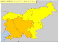
velja od 03.08.2010 09:00 CET Do 03.08.2010 22:00 CET
Nevihte Stopnja ogroženosti: Oranžna
en: Heavy thunderstorms are possible, accompanied by local intense precipitation, hail and gusty winds. sl: Možne so močnejše krajevne nevihte z nalivi. točo in močnejšimi sunki vetra.
3. avgust 2010Možne močnejše nevihte
Izdano 3.8.2010 ob 9.uri
Danes sredi dneva in popoldne bodo predvsem v vzhodni polovici Slovenije
krajevno možne močnejše nevihte z nalivi in sunki vetra. Ni izključen tudi
pojav toče.
3. avgust 2010
Ob nevihtah možen porast hudournikov
Izdano: 3.8.2010 ob 15:30
Danes popoldne in zvečer je na območju severne, jugovzhodne in vzhodne Slovenije možen porast manjših vodotokov in hudournikov.
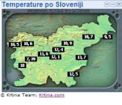
Vremenske karte
Wetterlage:(skywarn Avstrija)
Eine Kaltfront liegt quer über Österreich und überquert das Bundesgebiet bis zum Abend.
Vorderseitig wird in der Steiermark und Kärnten noch feuchtwarme und labil geschichtete Luft herangeführt.
Im Norden ist durch einen Trogdurchgang ebenfalls ein gewisses Gefährungdpotential vorhanden.
Das führt bereits ab den Morgenstunden zu gewittrigen Schauern im Alpenbereich und in weiterer Folge zu Gewittern im Süden und Südosten.
Vorhersage:
Ab den Morgenstunden sind von Oberkärnten über die westlichen Obersteiermark und Niederösterreich (Wald- und Mostviertel) Schauer und Gewitter vorherrschend.
Diese markieren die Kaltfront, die im Laufe des Tages Österreich von West nach Ost überquert.
Gleichzeitig bildet sich in Oberitalien ein Tief, das für weiteren Feuchtenachschub aus dem Süden sorgt.
In Unterkärnten, der Steiermark und dem südlichen Burgenland ist am Vormittag noch leichte Abschattung präsent, die die Bildung von Gewittern noch verhindert.
Diese Abschattung sollte bis Mittag vorbei sein, die daraus resultierende Erwärmung und Taupunkte um
Die Möglichkeit, dass die Kaltfront durch die Bildung des Italien-Tiefs und der Alpen rückläufig wird, ist ebenso gegeben - in diesem Falle könnte die Gewitterbildung erst später erfolgen und durchaus heftiger ausfallen.
Die Scherung ist heute hoch, sie erreicht in 1-8km rund 50 kts, in 0-6km 40 kts, daher ist heute die Gefahr von organisierten Gewittern mit Hagel bis zu max. 4cm und Sturmböen >120km/h stark erhöht.
Durch Rückdrehen der Strömung und bodennaher Wind aus O bis SO ist insbesondere in der südlichen Steiermark auch die Scherung in 0-3km erhöht, das bedeutet eine mäßige Gefährdung durch Superzellen und eventuellen Tornados.
Im Laufe des frühen Nachmittags können im Warnbereich somit Schwergewitter auftreten, die organisiert sein können und auch die eine oder andere Superzelle scheint heute möglich.
Im Bereich von Gewitterclustern können große Regenmengen fal


Radarska slika padavin(Lisca , Bilogora)


Nevihta doma:3.8.2010
Ob okoli 16:20 začelo deževat,padlo je 9mm(max inteziteta 30,2mm/hr ob 16:35)
Veter je potegnil pred nevihto do 38,6km/h 10,7m/s SZ ob 16:05


Pogled na nevihto nad ptujskim poljem

Nevihta katero sem čejsal(čejsal pa sem med 15-16 uro)


Dornava


Mostje(smer nevihte Desternik)


Ptuj(Podvinci)


Ni komentarjev:
Objavite komentar