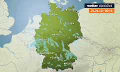
VP Orešje pri Ptuju 233 m

VP Orešje pri Ptuju 233 m
Nevihta nad jezerom, Radehova pri Lenartu 1.7.2022

četrtek, 14. maj 2015

Nevihti 13 in 14.5.2015 na območju Ptuja in doma

Zvečer je nas obšla nevihta. Tako doma kot na Ptuju je padlo par kapelj. Zapihal je le močan SZ veter (Arso Ptuj 56km/h ,doma 27,4km/h). Odpravil sem se na kratek čejs,vendar se n iujelo nič pametnega ,saj je nevihtna linija bila prehitra. Slikanje je motil nadležen Sz veter.


Storm Forecast
Valid: Wed 13 May 2015 06:00 to Thu 14 May 2015 06:00 UTC
Issued: Tue 12 May 2015 22:29
Forecaster: PUCIK / GROENEMEIJER
A level 2 was issued for E France, N Switzerland, SW Germany and extreme NW Austria mainly for (very) large hail, severe wind gusts, tornadoes and to the lesser degree for excessive
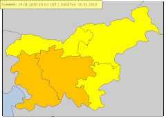
 precipitation.

A level 2 was issued for SE Austria and SW Hungary mainly for large hail, severe wind gusts and excessive precipitation.

A level 1 was issued for SE Germany and W Austria mainly for large hail, severe wind gusts and excessive precipitation.

A level 1 was issued for SW Slovakia and Hungary mainly for severe wind gusts, excessive precipitation and to the lesser degree for marginally large hail.

SYNOPSIS

A complex synoptic-scale scenario is forecast over Europe with a strong zonal flow forecast in between a ridge over the Mediterranean and a trough-ridge-trough complex over the northern half of Europe. Underneath the zonal flow, a diffuse frontal boundary is forecast to stall, stretching from the central France through S Germany eastwards. South of the boundary, tropical airmass will be advected in SW-ly flow from Iberia to S France and the Alpine region with EML from Iberia. With enhanced low-level moisture along the boundary, CAPE is forecast to build up along and south of the boundary underneath the strong westerly flow.

DISCUSSION

... E France through Alpine region into Hungary and SW Slovakia ...

A potentially dangerous but also highly questionable setup will develop over the region. NWP generally agrees on the impressive overlap of CAPE with strong DLS which should reach 25 - 35 m/s over the whole Level 2 area. Furthermore, as wind veers with height, SRH values should also reach above 200 m2/s2, especially near the border of Switzerland, Germany and France. The highest CAPE values are simulated over France and NW Switzerland, where the best overlap of low-level moisture and EML is likely with MLCAPE values between 1000 and 2000 J/kg. Towards the east, CAPE will be generally less.

With diffuse boundary and no strong forcing factor, convective initiation will become a crucial factor in this setup. CIN values should decrease as geopotential heights fall during the day and heating mixes the boundary layer. However, cloud cover and potential rain along the boundary may hinder the destabilisation. Low-level convergence zones along the boundary or induced by orography will likely be the primary initiation mechanism.

Due to the impressive kinematic environment, developing storms will likely become supercells, capable of large to very large hail and severe wind gusts. The highest threat of very large hail will be over E France, NW Switzerland and SW Germany. Towards the evening, as 850 hPa flow will increase and LLS will exceed 10 m/s. This should elevate tornado threat, which will be the highest over NW Switzerland, extreme E France and SW Germany. Storms rapidly tracking east to southeast will likely grow upscale in the evening hours, possibly forming an MCS over S Germany as PV max crosses the region. MCS could easily reach SW Slovakia and central Hungary by Thursday morning. Such MCS would pose threats of severe wind gusts as 0-3 km bulk shear exceeds 25 m/s and of excessive rainfall, especially over and close to the Alpine area.


Radarska slika v času slikanja med 20.45-21:35 uro.


Animacija prehoda padavinske slike čez SV Slovenijo


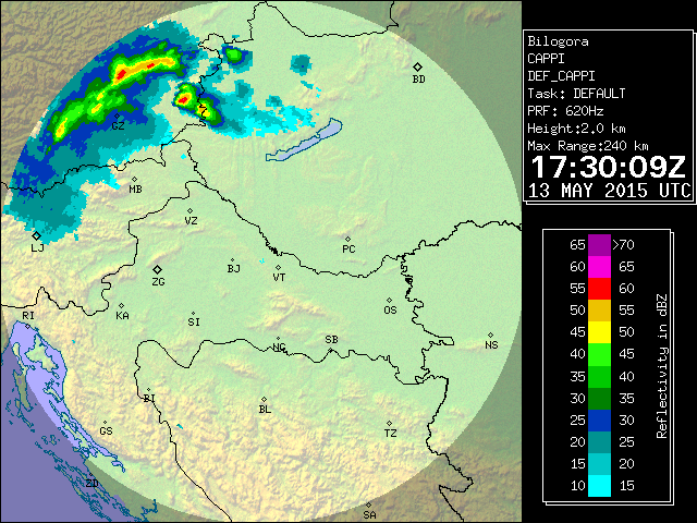
Udari strel ter satelitska slika oblačnosti


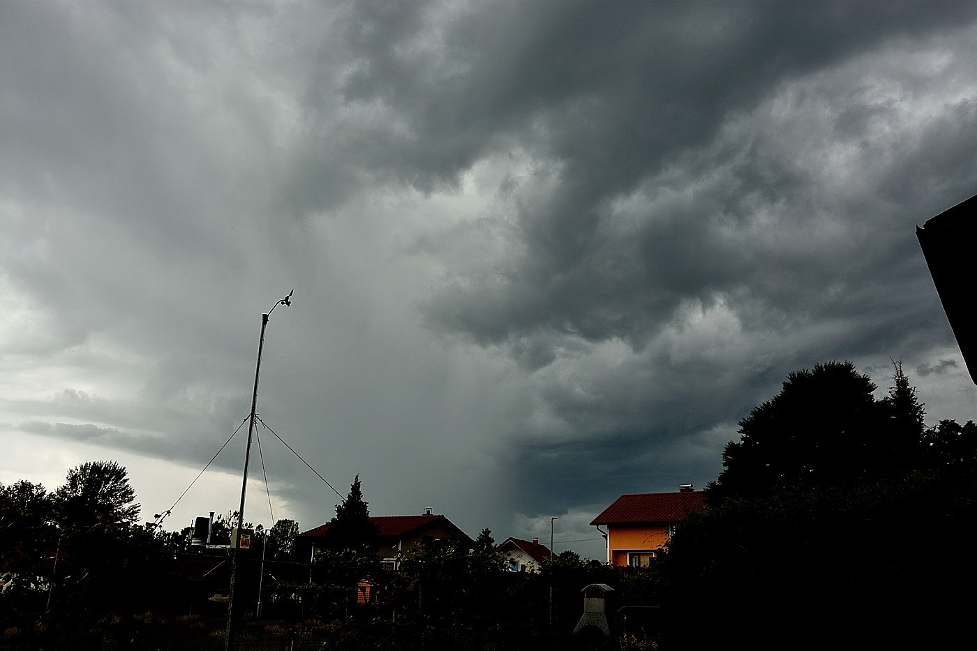
Jaz v akciji ,ter prvi preizkus dežne zaščite za fotoaparat,ki pa se ni najbolje obnesel,predvsem pri vetru.
Saj se je ob vetru  fotoaparat kljub temu tresel ,pa čeprav sem ga trdno držal,so bile slike zmazek.


Ujela se je le strela tipa clawer ,CG-jevke so pokale za gradom ter proti Ptujskim poljem. Tokrat sem izbral napačno lokacijo,upal sem namreč da bom ujel kakšno strelo nad gradom ,kar bi dodalo poseben čar. Le ko sem se peljal od doma je nad gradom udarila lepa CG-jevka žal sem bil prepozen.


Cg-jevke v ospredju luči ,ki vodijo na Puhov most
Zanimiva struktura ,nizka baza deluje kot wall cloud. Slike so nekoliko motne saj je pihal veter,kar je povzročilo tresljaje .


Zanimivi izrastki ,po vsej verjetnosti gre za scud cloud
Zapeljem se proti Dornavi,kjer še ujamem nekaj oddaljenih CG-jevk ,ki pa niso nič posebnega


Nevihta 14.5.2015 (Orešje)
Popoldan med 15:15 pa do okrog 16 ure nas je prešla manjša nevihta ,ki pa ni bila nič posebnega.(Prve 3 slike)
Kasneje je nekoliko južneje nastala še ena nevihta,ki pa je šla mimo nas. Kasneje so nastali eden lepših Pileus oblakov,kar je bilo danes še najbolj zanimivo.

Storm Forecast
Valid: Thu 14 May 2015 06:00 to Fri 15 May 2015 06:00 UTC
Issued: Thu 14 May 2015 06:38
Forecaster: GATZEN
A level 2 was issued for northern Italy and the north-western Balkans mainly for large hail and excessive precipitation, to a lesser extent also for tornadoes and severe wind gusts.

A level 1 was issued for south-eastern Fance and the northern and central Balkans mainly for large hail and to a lesser extent severe wind gusts and tornadoes.

SYNOPSIS

At the southern flank of a Scandinavian long-wave trough, an intense short-wave trough rapidly races across eastern Europe. In its wake, a cut-off low south of the UK will move south-east, crossing France during the period. Both troughs are associated with strong DCVA given the strong flow. A weak ridge will spread across France between both troughs.

At lower level, a sharp cold front extends from north-west Spain to southern France, the Alps, into the northern Balkans. Steep lapse rates south of this cold front overlap with rich low-level moisture that is situated south of the Alps, and also across the northern Balkans. Diurnal heating is most likely south of the Alps and parts of the Balkans, and CAPE can reach about 1000 J/kg according to latest GFS.

Currently, storms are going on across the northern Balkans and parts of the Alpine region. More storms forming during the period will pose a threat of severe weather due to the strong vertical wind shear.

DISCUSSION

Northern Italy into the central Balkans

An elevated mixed layer is present across the north Mediterranean indicated by latest soundings. It caps a rather moist boundary layer that will heat during the day allowing for CAPE around 1000 J/kg. From north-eastern Italy to the northern Balkans, a cold front slowly moves southward. Lapse rates will be weaker over this region, but can improve during the day in the wake of the Alps.

Current thinking is that thunderstorms evolve along and ahead of the cold front across the Balkans and over north-eastern Italy. Strong deep layer vertical wind shear (more than 20 m/s in the lowest 6 km) supports well-developed multicells, capable of producing large hail and excessive rain. Additionally, locally enhanced SRH can result in supercells with very large hail the main threat, but also tornadoes and severe wind gusts are not ruled out.

Later in the period, approaching trough and jet streak from the west will likely assist initiation further west across northern Italy. Lee cyclogenesis results in strongly veering profiles and SRH around 150 J/kg. Supercells, capable of producing very large hail. Low-level vertical wind shear is expected to be relatively weak, limiting the chance of tornadoes, but every isolated supercell that forms will also pose a tornado threat.

Increasing DCVA is expected to support rapidly clustering of the storms, forming one or two MCSs, moving south-east. Excessive precipitation, severe wind gusts, and large hail are forecast to be the main threat, but tornadoes are also not ruled out given increasing low-level vertical wind shear.

Eastern Europe

In the range of the passing short-wave trough, storms are expected to develop due to moist low-level air masses and steep mid-level lapse rates. Chances of severe convection are expected across the northern Balkan States along the cold front, where best moisture is expected and vertical wind shear is strongest with around 15 m/s in the lowest 3 km. Limiting factor will be weak diurnal heating due to convective clouds from the morning storms. A level 1 is issued mainly for large hail, but severe wind gusts and tornadoes are not ruled out completely.


Manjša nevihta med 15-16 uro je dala le 2,2mm padavin.


Pogled na na mimohod še ene nevihtne celice.


Eden lepših Pileusov v zadnjem času.

 Dežna zavesa na območju Donačke gore.


 dežna zavesa


Ni komentarjev:

Naj 5 dogotkov v letu 2012

Naj 5 vremenskih dogodkov v letu 2012


1. Huda vročina in suša v drugi polovici avgusta(15-25.8.2012)
Avgusta sta nas zajela dva močna vročinska vala. Prvi je trajal od 1 do 6 avgusta,najvišja temperatura je bila dne 5 avgusta in sicer 34,7 stopinj C.
Med 15 in 25 avgustom,nas je zajel izjemno hud vročinski val. Ponekod v jugovzhodni Sloveniji so bile temperature tudi do 39 stopinj C. Na vremenski postaji Orešje pri Ptuju je bila zabeležena najvišja avgustovska temperatura in sicer 36,6 stopinj C dne 22.8.2012. Povprečna mesečna temperatura v avgustu je bila 22,0 stopinj C,kar je nov rekord. Med 1-26 avgustom je bila povprečna temperatura celo 22,5 stopinj C. Vročinski val je trajal kar 11 dni,v tem obdobju je padlo le 1,2mm dežja(23.8). V celem avgustu pa samo 24 mm dežja. Zaradi hude suše je začelo odpadat listje z dreves. Po 26 avgustu je vročina popustila.

Slike suše

Tabela max. temperatur med 15-25 avgustom.

Datum
Tmax.
Čas izmerjene temperature
15.8.2012
30,5 °C
17:10
16.8.2012
30,6 °C
16:18
17.8.2012
30,7 °C
18:25
18.8.2012
30,5 °C
16:30
19.8.2012
32,4 °C
17:19
20.8.2012
35,1 °C
16:28
21.8.2012
35,6 °C
17:19
22.8.2012
36,6 °C
17:05
23.8.2012
32,9 °C
18:15
24.8.2012
36,4 °C
16:43
25.8.2012
34,8 °C
17:30

2. Viharni jugozahodni veter 25.12.2012
Izjemno vetroven Božični dan. Sunki jugozahodnega vetra so po nižinah dosegali do 80km/h ,v nekoliko višjih legah pa do 100km/h. Tako doma kot na sosednjem hribu(Sovretova pot 300m) je bil zabeležen nov rekord. Na VP Orešje pri Ptuju je bil največji sunek izmerjen ob 10:09 in sicer 61,2km/h(sunki so bili tudi do 75km/h,zaradi sunkovitega vetra se je konstrukcija vremenske postaje ob večjih sunkih zamajala,zato so bili dejanski sunki nekoliko večji). Povprečna dnevna hitrost vetra je bila 16,3km/h. Med 10:30-11:10 sem z ročnim merilcem(Windmaster 2) meril na bližnjem hribu,kjer je izrazito izpostavljena lega za JZ veter. Izmeril sem rekorden sunek vetra in sicer 90km/h(25m/s) ob 11:02. Omenjen sunek spada po 12 stopenski Beaufortovi lestvici pod močan vihar(10 stopnja). Sunki so bili med 12-14 uro lahko blizu 100km/h.


Slikovna napoved(Vir.Arso)


Podrto drevo ,Orešje-Sovretova pot pri Ptuju.Vir:24ur.com


Modelska napoved največjih sunkov vetra(Aladin)

Veter je povzročil ,kar nekaj škode(Vir Rs za zaščito)

Beaufortova lestvica: 10

m/s 24.5 - 28.4
km/h 88 - 102
vozli 48 - 55
povprečna hitrost vetra v vozlih/km/h/mph: 52 / 96 / 60
opis vetra: močan vihar (tempesta, unwetter, storm)
učinek na kopnem: dviga strehe in podira drevesa
učinek na morju: gladina "zamegljena" (very high waves, the sea surface is white and there is considerable tumbling, visibility is reduced)
višina valov: 9 (~ 29,5 ft)
Mediji
Intervencije
http://www.sos112.si/db/priloga/p15779.pdf
Analiza vremena 23-26 december(Arso)
http://meteo.arso.gov.si/uploads/probase/www/climate/text/sl/weather_events/visoka-temp-veter_23-26dec12.pdf

Video močnega vetra Orešje pri Ptuju(Matej Štegar)


3. Sneženje ter hud mraz od 2 do 14.2.2012

Sneženje 4.2.2012
Dopoldan začel naletavat sneg,ki se je okrog 11 ure okrepilo v rahlo do zmerno sneženje.
Sneženje je ob okoli 21:00 ure ponehalo. Zapadlo je 3,5cm suhega snega. Količina padavin je bila 0,8mm. Občutek mraza je bil najvišji ob 18:04 in sicer -13,3.C.
Sneženje 6-7.2.2012
Ob okoli 7:30(6.2.012) je začelo rahlo snežit,ki se je dopoldan nekoliko okrepilo v zmerno sneženje. Popoldan je za krajši čas ponehalo ,vendar se je proti večeru ponovno okrepilo.
Do 20:30 padlo 6,5cm novega ,skupna višina je znašala 8,5cm. Količina padavin je bila 2,6mm.
Sneženje se je nadaljevalo v noč na torek,in v torek popoldan ponehalo. Skupaj z (6.2.012) je padlo 17cm suhega snega. Količina padavin je 7.2.2012 bila 6,6mm.
Tudi maksimalna dnevna temperatura je bila zelo nizka ,in sicer v ponedeljek(6.2) je bil dnevni maksimum le -7,9°C . V torek (7.2) pa -7,3°C .

Hud mraz 8 in 9.2.2012 ,in zaledenela reka Drava 8.2.2012
Nad nami je prevladoval hladen sibirski zrak.
V torek 7.2.2012 se je zvečer ob okoli 21:00 razjasnilo. Temperatura je zaradi jasnega in mirnega ozračja ter snežne odeje(suh sneg) začela hitro padat. Do polnoči je padla na -11,7°C (ob 23:33). V sredo zjutraj 8.2.2012 ,je bila najnižja temperatura -17,2°C (ob 6:32),na 5cm nad snežno odejo je bila temperatura -22,4°C .

Tudi v sredo zvečer(8.2.202) je temperatura izjemno hitro padala.
Pad temperature po urah.
Ob 20:00, -12,7°C
Ob 21:00, -13,8°C
Ob 22:00, -14,6°C
Ob 23:00 , -15,4°C
Četrtkovo jutro(9.2.2012) je bilo izjemno mrzlo,najnižja jutranja temperatura je bila -18,4°C ob 2:58. Če se ne bi proti jutru pooblačilo bi bil z lahkoto dosežen nov rekord. Temperatura 5cm nad snežno odejo je bila kar -23,9°C. Temperatura na Dravskem in Ptujskem polju se je mestoma spustila do okoli -21,0°C .
Še minimalne temperature v obdobju med 2 in 14 februarjem
Datum
Tmin.
Čas izmerjene temperature
2.2.2012
-9,7°C
7:45
3.2.2012
-10,9°C
7:15
4.2.2012
-9,2°C
20:45
5.2.2012
-10,4°C
7:06
6.2.2012
-10,4°C
3:15
7.2.2012
-11,7°C
23:33
8.2.2012
-17,2°C
6:32
9.2.2012
-18,4°C
2:58
10.2.2012
-11,2°C
5:31
11.2.2012
-10,0°C
4:00
12.2.2012
-8,6°C
0:15
13.2.2012
-9,2°C
7:15
14.2.2012
-13,9°C
6:16

Več na blogu

4. Katastrofalne poplave reke Drave 5-6.11.2012
Reka Drava je začela naraščat zgodaj zjutraj(5.11) med 10-11 uro se je začela razlivat na območju vsakoletnih poplav. Ker so se čez noč karte spremenile je bilo največ padavin na Gorenjskem ter Koroškem ter tudi na avstrijski strani. Tudi meja sneženja je bila zelo visoko in je dodatno pripomogla k naraščanju Drave. Avstrijske hidroelektrarne so zgodaj zjutraj obvestile Arso,da bodo ob okoli 12 ure spustile ogromno količino vode tam okoli 2000m/s3. Zato je bilo za zgornjo in spodnjo Dravo razglašen rdeč alarm pred silovitimi poplavami. Največji pretok reke Drave je bil do zdaj leta 1965 2600m/s3 . Tokratni pretok je bil na Ptuju ocenjen med 3100-3200m/s3. Najvišji vodostaj je bil med 19uro zvečer(5.11)in 1uro zjutraj.
V Orešju pa so pri reševanju pomagalo tudi okoli 20 vojakov in nekaj gasilcev.

Nekaj video posnetkov tega izjemnega dogodka.

Naraščanje Drave(med 10-11uro)

Reportaža


5. Sneženje konec oktobra (28-29.10.2012)
Med 2:30-3:30(28.10)je 4x zagrmelo,ob okoli 2:30 je dež prešel v zmerno do močno sneženje. Med okoli 5-6 uro smo bili brez elektrike,ter še nekaj malega čez dan. Veliko vej,dreves je bilo polomljenih.
Ob 8 uri sem izmeril na beli leseni deski ,kar 6,5cm južnega snega ,skupaj je najvišja snežna odeja znašala 7cm. Popoldan je bilo večinoma suho ,ob okoli 15.55 je začel ponovno dež s snegom .Zvečer ter v drugem delu noči(29.10) je rahlo snežilo padlo je dodatnih 4cm,tako je bila najvišja snežna odeja v oktobru od kar merim(2001)9cm ob 8uri(29.10). V tem poslabšanju od 26-29.10.2012 je padlo skupaj 77,2mm padavin. Dne 26.10(3,6mm)27.10(41,8mm)28.10(29,6mm)29.10(2,2mm). Skupna akumulativa zapadlega snega je bila 11cm. Na vremenski postaji Mestni vrh 320m sem v ponedeljek(29.10) ob 10uri izmeril kar 15cm.

Bohinj 5.3.2011(Srečanje ZEVS)

Bohinj 5.3.2011(Srečanje ZEVS)

VP Orešje v štajerskem Tedniku

VP Orešje v štajerskem Tedniku

Trenutne temperature po Sloveniji(Amaterske postaje)

Arhiv podatkov(Postaje Zevs)

Statistika vremenskih podatkov(Zevs)

Radar Lisca

Radar Bilogora (Hrvaška)

Radar Osmer

Radar Nemčija

Meteoalarm

Kontakt:

Matej Štegar:Član vremenskega društva ZEVS
e-mail : mstegar@gmail.com
gsm: 040644540
Nov spletni blog numizmatika:http://numizmatika-matej.blogspot.com