

... Italian E coast, Adriatic Sea, Croatia, Slovenia, SE Austria, SW Hungary, Bosnia-Herzegovina, Serbia, Montenegro, Albania ...
Steep lapse rates, originally created over the Sahara desert and reinforced over the Appennines and the Dinaric mountains, spread over the area of interest. With 2m dewpoints of 16-20C over the Pannonian plains and up to 23C over the Adriatic Sea, around 2000 J/kg of CAPE are predicted to build on Friday, locally even more. Warm air advection will create a pronounced cap, but lift ahead of the cut-off low will start to increase from the SW as the day proceeds. At the same time, vertical wind shear rises to 15 m/s (20 m/s) across the lowest 3 (6) km under slightly veering profiles.
Scattered convection will likely still be left over from the previous night over N and E Italy or will form already before noon, aided by increasing synoptic lift and a mess of outflow boundaries and other disturbances of the low-level wind field. Competition and destructive interference may lower the severe weather risk somewhat, but at least scattered large hail, severe wind and heavy rain events are expected with this activity. Tail-end storms towards the southeast may organize best into supercells.
It is worth mentioning that the majority of the model pool, including convection-permitting models like WRF and MOLOCH, predict scattered activity across the northern and central Adriatic Sea throughout the forecast period. Scirocco winds would advect a very moist boundary layer with enhanced 0-1 km shear into these storms, which would very likely become supercellular. If such a high storm coverage over the Adriatic Sea indeed verifies, numerous tornadoes could form, most of them well off the coastlines, though.
In the evening and overnight, clustering storms will increasingly move onshore or form anew in coastal Croatia, Montenegro and Albania with a gradually decreasing but still enhanced risk of all kinds of severe weather.
Further north and east of the Adriatic Sea, it is most difficult to assess where and when the cap will be broken. Convective initiation will stay isolated at best until mid-afternoon. Possible sites for solitary early "cap breakers" are the southern Alps (if upvalley flow is strong enough) or outflow boundaries, laid out by several storm clusters from the previous night that are moving northward in E Austria and W Hungary near the nose of the warm air advection regime at the time of writing (Thu 22 UTC). Despite an expected struggle against the cap, these early storms, if they form, may already organize well and bring large hail.
In the course of the afternoon, the probability of convective initiation rapidly increases over the Dinaric mountains in W Slovenia and NW Croatia. While vertical mixing will keep both CAPE and wind shear lower in these initiating regions, storms will quickly intensify and organize as soon as they tap into the abundant CAPE reservoir and better shear further northeast. Convection-resolving models agree on quick upscale growth into a large MCS with a most likely track across much of Slovenia in the evening, including the bordering regions of Croatia and Austria. Supercells will likely bring large to very large hail in initiating stages or generally at the southern flank of such a system. In addition, a tornado is not ruled out, though this risk is mitigated by not too low cloud bases and rather inconspcuous low-level shear. Along the MCS's main body, severe straight-line winds will betimes become the main risk. They may become quite widespread and include some extreme events (>32 m/s).
The mature and finally slowly weakening MCS could persist well into the night or even into the next morning while it continues its track northeastward into E Austria, Hungary and possibly even Slovakia. It will likely bring a prolonged period of heavy rain, and flash floods become another dangerous hazard in the course of the night, especially in S and E Austria where soils are often already saturated. In addition, severe wind gusts or large hail are still possible at the leading edge or under more discrete updrafts, respectively.
Similarly abundant CAPE and enhanced vertical wind shear is expected over the eastern parts of Croatia and Bosnia-Herzegovina as well as in Serbia, but the capping inversion will be stronger towards the south (indicated by the Thu 12 UTC Trapani, Pratica di Mare and Brindisi soundings) and synoptic lift arrives later and stays weaker. It is uncertain whether the cap can be broken at all. However, every storm that forms over the Dinaric mountains and descends into the Pannonian plain can easily become supercellular with a risk of large to very large hail. Severe downbursts and flash floods become additional hazards in case convection manages to grow upscale. In that case, it may also persist into the evening and night.

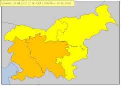
Verjetna so številna močna neurja s točo, močnejšim pišem vetra in udari strel. Toča lahko lokalno uniči posevke. Ob hudourniških vodotokih so možne silovite poplave. Zelo verjetne so poplave meteorne vode. Udari strel lahko zanetijo požare. Veter lahko ruva drevesa in odkriva strehe.Verjetna so številna močna neurja s točo, močnejšim pišem vetra in udari strel. Toča lahko močno poškoduje ali uniči posevke. Ob hudourniških vodotokih so možne silovite poplave. Zelo verjetne so poplave meteorne vode. Udari strel lahko zanetijo požare. Veter lahko ruva drevesa in odkriva strehe. Lahko je motena oskrba z električno energijo, moten je promet. Aktivnosti na prostem so lahko življenjsko nevarne.Med nevihto se ne odpravljajte na pot, če ni nujno potrebno. Počakajte na varnem mestu, na prostem poiščite zavetje v zgradbah ali v vozilu. Med nevihto se ne zadržujte pod drevesi ali daljnovodi, udar strele je smrtno nevaren! Ne zadržujte se v bližini hudourniških vodotokov. Ne izpostavljajte se, ko pada toča, zrna vas lahko poškodujejo. Ne parkirajte pod drevesi.Bodite pozorni na bližajoče se nevihtne oblake. Med nevihto se ne odpravljajte na pot, če ni nujno potrebno. Počakajte na varnem mestu v zgradbi in zaprite vsa okna. Če vas nevihta ujame na prostem, čim hitreje poiščite zavetje v zgradbah ali v vozilu. Na prostem ne prenašajte kovinskih predmetov. Med nevihto se tudi v zgradbah ne dotikajte kovinskih predmetov. Izključite elektriko. Udar strele je smrtno nevaren! Če je možno, pravočasno umaknite vozila v garažo. Ne izpostavljajte se, ko pada toča, zrna vas lahko poškodujejo. Ne parkirajte pod drevesi, piš vetra lahko lomi veje ali izruva drevo. Računajte na ovire v prometu. Ne zadržujte se v bližini hudourniških vodotokov.
Vir: Meteoalarm


Sondaža Ptuj


Ob 12:30 smo se z Alešem in Jernejem dobili na Ptuju, kjer smo se ohladili z
 .
Malo po 13 uri krenemo proti Karlovcu, kjer je bil naš primarni cilj.
Na poti zlasti čez Puhov most je bila velika gneča. Na meji na srečo ni
bilo tako hudo, čakali le cca. 15 minut. Malo čez mejo opazimo na
radarju prvo nevihto na območju Ogulina, ki je postajal vse močnejša, in
imela smer proti Črnomlju. Ker je teren tam gričevnat, smo iskali na
google mapsu primerno lokacijo. Aleš je našel, blizu meje odlično
lokacijo v kraju Zaluka-Lipnička v občini Žakanje.
.
Malo po 13 uri krenemo proti Karlovcu, kjer je bil naš primarni cilj.
Na poti zlasti čez Puhov most je bila velika gneča. Na meji na srečo ni
bilo tako hudo, čakali le cca. 15 minut. Malo čez mejo opazimo na
radarju prvo nevihto na območju Ogulina, ki je postajal vse močnejša, in
imela smer proti Črnomlju. Ker je teren tam gričevnat, smo iskali na
google mapsu primerno lokacijo. Aleš je našel, blizu meje odlično
lokacijo v kraju Zaluka-Lipnička v občini Žakanje.Tukaj smo imeli idealen pogled na mrcino

Naša lokacija, označena na radarju.

Pogled na izjemno supercelico z ogromnim wall cloudom.


Še en hiter timelapse
https://youtu.be/BLzCxTy5Flo
Usedemo se v avto, na kar hitro opazimo sumljivo vrtinčenje. Hitro pograbimo fotoaparate in začnemo šklocat. Adrenalin ob prvem pogledu na funnel cloud je stekel po žilah. Ali je šlo tudi za tornado ne bo nikoli jasno, morda je celo bil za par minutk na tleh.


Hitro je razpadlo, viden je bil le še wall cloud.


Odpeljemo se nazaj v smeri Karlovca. Na hitro pred nami nastane nova left moverca.


Ena hitra z avta in bežimo pred točo, hrkrati pa šiščemo lokacijo z katere bi lahko slikali. Do prvotne lokacije se ni izšlo ker so nas kmalu zajele močne padavine. Supercelica pa je že izgubljala na obliki.
Kraj Ribnik

Za supercelico, ki je potovala, domala po avtocesti med Karlovcem in Zagrebom pa nismo mogli, saj bi se zapeljali direkt v točo.
Kasneje smo se odpeljali po avtocesti do Varaždina, da bi ujeli sup na Ptujem. Sprva smo še bili dovolj hitri, kasneje ko pa se je zagrebška sup združila z Ptujsko pa je linija podivjala, in ji nismo več mogli slediti. Z avta sem uspel naredit le dve fotki te supercelice.
Radar in lokacija


V kraju Velika Nedelja poskušamo ujeti shelf cloud, ki pa je hitro razpadel.

Gasilci so imeli polne roke dela. Veliko je bilo poplavljenih hiš, kamenja in blata na cestah.

Še nekaj slik od supercelice doma(Avtor, Damijan Kozel, in Edvard inTomaž Štegar)


Ni komentarjev:
Objavite komentar