
Storm Forecast
Valid: Thu 14 Jul 2011 06:00 to Fri 15 Jul 2011 06:00 UTC
Issued: Wed 13 Jul 2011 22:34
Forecaster: GATZEN
A level 1 was issued for the northern Balkans, Slovakia, and southern Poland mainly for large hail.
A level 1 was issued for the southern Baltic States and northern Poland mainly for tornadoes.
A level 1 was issued for northern Italy mainly for large hail.
A level 1 was issued for northern Algeria and Tunisia mainly for large hail and severe wind gusts.
SYNOPSIS
A trough over western Europe slowly spreads eastward. A strong mid-level flow ahead of the trough extends from the north Mediterranean Sea to the Baltic Sea. A corresponding surface low is centred over the Benelux countries, with a frontal boundary from central Poland to southern Austria and northern Italy.
DISCUSSION
Northern Balkans and surroundings
On Thursday, the strong south-westerly mid-level jet will continue to affect the northern Balkans. The associated surface cold front has reached Croatia and is expected to remain during the period. Above the boundary-layer, an elevated mixed layer is advected with southerly winds ahead of a low over northern Italy. Intense moisture pooling at low levels and diurnal heating will lead to CAPE values in the order of 2000 J/kg.
Initiation of storms is expected along the frontal boundary. Some more storms are also possible over the mountains farther south. The convective activity is also expected to increase in the afternoon hours due to an approaching mid-level vort-max. Organized storms are expected due to the strong vertical wind shear (0-3km bulk shear 20 m/s, 0-6km bulk shear 25 m/s). Besides multicells, supercells capable of producing very large hail, excessive precipitation, severe wind gusts, and tornadoes are forecast given favourably veering profiles. The storms will likely merge to mesoscale convective systems spreading north-east, or eastward. Bowing lines that increase the wind threat are not ruled out. Late in the period, these storms are forecast to spread into Hungary, where severe wind gusts are forecast to be the main threat.
Slovakia, eastern Poland
The frontal boundary will be associated with strong low-level convergence over central/eastern Poland and western Slovakia, where the low-level mixing ratio will increase to 7 g/kg. With southerly winds, warm air advection is forecast in the afternoon that is also associated with the advection of steep lapse rates. Diurnal heating is expected to result in more than 1000 J/kg CAPE or more in the afternoon.
Current thinking is that the convective activity will increase in the afternoon hours due to QG forcing and increasing low-level convergence, especially over Slovakia and southern Poland. Given strong vertical wind shear and also increasing storm-relative helicity in the afternoon, supercells are forecast, capable of producing large or very large hail. Additionally, excessive precipitation, severe wind gusts, and tornadoes are not ruled out. The storms are expected to cluster along the frontal boundary where they may go on until the morning hours.
Southern Baltic States and northern Poland
Ahead of the cold front, a warm front is expected to spread northward across the Baltic States. A moist and increasingly unstable air mass spreads northward during the period that will affect especially northern Poland and Lithuania. Thunderstorms are expected to develop through-out the period given weak CIN values and relatively strong low-level convergence, especially near the frontal boundary. Some of the storms may organize given 15 m/s 0-6km bulk shear, and locally large hail is forecast. Additionally, tornadoes are not excluded with the highest chance near the warm front, where favourably veering profiles and instability may overlap. The storms are forecast to weaken during the night hours.
Northern Italy
In the wake of the surface low, a weak northerly flow is forecast on Thursday. Given rather rich boundary layer moisture diurnal heating is forecast to result in CAPE. Initiation becomes more likely in the afternoon when a mid-level vort-max approaches. Although the vertical wind shear will decrease, stronger storms are expected to produce large hail locally.
14. julij 2011
Močne nevihte
Izdano 14.7. ob 6:00
Danes popoldne in zvečer so predvsem na Koroškem, Štajerskem in v Prekmurju možne močnejše nevihte s točo, nalivi in močnimi sunki vetra.
velja od 14.07.2011 13:00 CET Do 14.07.2011 23:00 CET
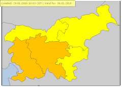
Nevihte Stopnja ogroženosti: Oranžna
en: Slovenia / North-East : en: Heavy thunderstorms are possible, accompanied by local intense precipitation, hail and gusty winds. sl: Slovenija / severovzhod : sl: Možne so močnejše krajevne nevihte z nalivi. točo in močnejšimi sunki vetra.
velja od 14.07.2011 01:00 CET Do 14.07.2011 23:59 CET
Izjemno visoke temperature Stopnja ogroženosti: Rumena
en: Slovenia / North-East : en: sl: Slovenija / severovzhod : sl:


Supercelična nevihta v Murski Soboti malo po 12 uri.
Padala toča v velikosti oreha (4-5cm)


Začetek proženja padavin(ob 18.45 uri)


Prva HP supercelica z točo


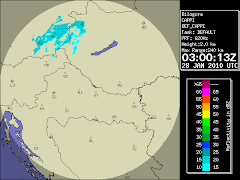
Odboji med 50-55dbz(nevihta s točo)


Prihod druge HP Supercelice


1.HP Supercelica z točo z premerom 3cm
Ob okoli 18:50 je iz smeri Podlehnika nastala prva supercelica ,ki se je hitro pomikala v smeri SV-S.V nevihti je padlo 3mm dežja ,toča z premerom 2,5cm mestoma do 3cm,vetra je bilo zelo malo tam do 20km/h, razen pred nevihtnim dogajanjem ko je pihal SV veter do 30km.Toča je padal med okoli 19:03-19:08 uro.


2.HP Supercelica z parim zrni toče 1cm
Ob 19:45 nova supercelica,ki je imela isto smer kot prva.Padala je toča v velikosti 1cm,glavnina je šla malenkost severneje.
Padlo je 7,6mm ,inteziteta padavin je bila 80mm/hr ,rosišče se je gibalo med 18-19.C ,vetra je bilo ponovno zelo malo.
Nevihta je ponehala ob 20:20 ,do okoli 22 še je grmelo in občasno kapljalo.


Inflow tail


Wall cloud




Ni komentarjev:
Objavite komentar